VANCOUVER, BC / ACCESS Newswire / June 24, 2026 / Faraday Copper Corp. ("Faraday" or the "Company") (TSX:FDY)(OTCQX:CPPKF) is pleased to announce the results of 18 drill holes from its Phase IV drill program at the Copper Creek Project, located in Arizona ("Copper Creek"). Five holes were drilled in the American Eagle area and targeted near-surface copper mineralization. Six holes were drilled near Mammoth and Childs Aldwinkle and had infill, geotechnical and hydrogeological objectives. Seven reconnaissance exploration holes were drilled, with two in the Sunrise trend, three at Marsha's Pocket, one west of Old Reliable and one east of Copper Giant.
Paul Harbidge, President and CEO, commented, "I am pleased with the drill results to date, particularly in the American Eagle area, which continue to increase our confidence in the potential contribution from this area in the next mineral resource update. The identification of oxide copper mineralization east of Copper Giant highlights the opportunity to add further oxide resources and bolster the potential for early cathode production. Additionally, drilling at the Sunrise trend has demonstrated the presence of breccia and porphyry style veins outside of the current resource area and we look forward to further testing these targets."
The primary objective of the current drill program was open pit resource definition, which has now been completed. With the proposed acquisition of the San Manuel Property, drilling has been paused as of June 20, 2026. The Company expects to resume drilling in the fall of 2026 once the proposed acquisition of San Manuel has closed.
Highlights
-
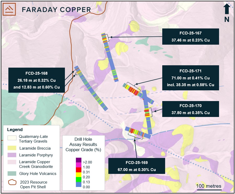
Intersected near-surface mineralization in four shallow-angled drill holes in the American Eagle area, including:
35.35 metres ("m") at 0.58% copper from 85.40 m, within 71.00 m at 0.41% copper from 80.00 m in hole FCD-26-171; and
67.00 m at 0.30% copper from 30.00 m in hole FCD-26-169.
These drill holes tested the top 50 m below surface, where previous drill data was scarce, and increase the confidence in adding near-surface mineralization.
Identified previously undrilled copper oxide mineralization east of Copper Giant. Intersected 37.00 m at 0.45% copper (0.36% acid soluble copper) from 20.00 m, within 73.00 m at 0.31% copper (0.22% acid soluble copper) starting at surface in drill hole FCD-26-173.
Reconnaissance drilling in the Sunrise trend intersected hydrothermal breccia and porphyry style veins, suggesting the presence of a porphyry centre approximately 1.5 kilometres ("km") south of the American Eagle area, which warrants follow-up drilling.
(For true width information see Table 1)
American Eagle area
The American Eagle area, as mapped on surface, covers approximately 800 m by 1,000 m and is host to numerous prospective breccias and porphyries. These surface expressions are located above the large underground porphyry mineral resource1. Previous drilling by Faraday resulted in the discovery of numerous mineralized breccias including Banjo, Winchester and Prada. Five holes were completed in the area, four of which intersected significant copper mineralization within 40 m from surface.
Drill hole FCD-26-167 was collared approximately 200 m northwest of the American Eagle breccia and drilled at a shallow angle to the northwest, targeting near-surface mineralization near the Jailhouse breccia. It starts in granodiorite to 40 m, followed by igneous cemented breccia to 83 m. Thereafter, the hole intersected alternating porphyry and granodiorite domains to 170 m, where it enters a zone of breccia and porphyry to 222 m. The hole ends in granodiorite. Alteration in the breccia zone is potassic, overprinted by sericite. Mineralization occurs as chalcopyrite with pyrite in breccia cement and porphyry style veins. At the start of the hole, chrysocolla and copper bearing manganese oxide are present.
Drill hole FCD-26-168 was collared west of American Eagle and drilled to the northwest, targeting a possible southwest-ward extension of the Jailhouse breccia trend. The hole intersected granodiorite to 442 m followed by alternating breccia and granodiorite to 503 m. The hole ends in granodiorite. Mineralization is associated with porphyry-style veins and sericite alteration and consists of pyrite and chalcopyrite. Breccias contain locally abundant chalcopyrite and pyrite as cement.
Drill hole FCD-26-169 was collared near the American Eagle breccia and drilled at a shallow angle to the west, targeting near-surface supergene mineralization. The hole intersected granodiorite to 37 m, followed by igneous cemented breccia to 47 m and porphyry to 95 m. Granodiorite is dominant to the end of the hole with an igneous breccia domain from 103 m to 111 m. Mineralization occurs as chalcocite with variable amounts of pyrite and trace chalcopyrite disseminated in porphyry and in porphyry-style veins.
Drill hole FCD-26-170 was collared near the American Eagle breccia and drilled at a shallow angle to the north, targeting near-surface supergene mineralization. After 30 m of granodiorite it intersected breccia to 74 m. Porphyry with some igneous cemented breccia dominates to 105 m. Granodiorite is present to the end of the hole with sections of porphyry from 148 m to 178 m. The breccia domain is strongly oxidized. Chalcocite is present in porphyry style veins together with chalcopyrite and pyrite and in trace amounts throughout the breccia.
Drill hole FCD-26-171 was collared north of the American Eagle breccia and drilled at a shallow angle to the northwest, targeting near-surface supergene mineralization. The hole intersected granodiorite to 43 m, followed by a zone of breccia alternating with porphyry to 121 m before entering granodiorite to the end of the hole. Mineralization occurs as chalcocite together with pyrite in breccia cement and porphyry-style veins. Chalcopyrite is present in trace amounts.
Copper Giant East
Drill hole FCD-26-173 was collared east of Copper Giant and drilled to the south, testing a previously undrilled area for copper oxide mineralization. The hole intersected porphyry for the first 14 m before entering a granodiorite zone with local breccia domains to 92 m. The hole entered porphyry to 132 m and granodiorite to the end of the hole. Copper occurs as chrysocolla, malachite and tenorite as fracture coatings and disseminated in the first approximately 73 m of the hole. Trace chalcocite and chalcopyrite are observed thereafter.
Sunrise trend
The Sunrise trend is located approximately 1.6 km southeast of American Eagle and is characterized by the presence of hydrothermal breccias and several corridors of sericitic alteration controlled by northwest trending faults. Copper oxide occurrences and veins anomalous in precious metals have been identified through geological mapping and sampling. The area has not been drill-tested previously. Two reconnaissance holes, as described below, were drilled and intersected porphyry style veins and hydrothermal breccias. These first reconnaissance holes suggest the presence of a porphyry centre south of and separate from American Eagle. Follow-up drilling is planned.
Drill hole FCD-26-146 was collared at the Sunrise trend and drilled to the northeast, targeting a previously undrilled breccia and structural zone. Breccia cross cutting granodiorite was intercepted from 151 m to 158 m and from 291 m to 345 m. Breccia domains are sericite altered and contain pyrite cement with trace amounts of chalcopyrite. Porphyry style veins with quartz-pyrite and chalcopyrite occur below 350 m.
Drill hole FCD-26-147 was collared at the same location as FCD-26-146 and drilled to the north. It intersected granodiorite to 315 m followed by a zone of alternating breccia and granodiorite to 556 m. Glory hole volcanics are present to 604 m, after which the hole intersected granodiorite once again. Glory hole volcanics were also intersected in the last 20 m of the hole. Breccia domains are sericite altered and contain pyrite cement with trace amounts of chalcopyrite. Porphyry style veins with pyrite and, locally, chalcopyrite occur throughout the hole.
Infill Drilling near Mammoth and Childs Aldwinkle
Seven drill holes tested areas with limited previous drilling near the well-defined and mineralized Mammoth, Childs Aldwinkle, White Bear and Pole breccias. These holes also had geotechnical and hydrogeological objectives.
Drill hole FCD-26-145 was collared near the White Bear breccia and drilled to the east in an area with limited drilling west of the Childs Aldwinkle breccia. The hole stayed in granodiorite for its entire length. Mineralization occurs as pyrite and chalcopyrite and trace amounts of bornite in porphyry style veins. The hole was terminated before the target depth due to drilling equipment challenges and was followed up by drill hole FCD-25-156.
Drill hole FCD-25-156 was collared at the same location as FCD-25-145 and drilled to the southeast in an area with limited drilling west of the Childs Aldwinkle breccia. The hole intersected granodiorite except for a porphyry interval from 580 m to 622 m. Mineralization includes chalcopyrite with pyrite occurring in porphyry-style veins and disseminated within the porphyry interval. This drill hole was also designed for rock-permeability testing for future hydrological models.
Drill hole FCD-26-157 was collared near the White Bear breccia and drilled to the south, collecting drill data between known mineralized centres. It intersected granodiorite for its entire length. Mineralization occurs as pyrite-chalcopyrite with trace chalcocite in porphyry style veins associated with sericitic alteration.
Drill hole FCD-26-158 was collared northeast of Childs Aldwinkle and drilled to the north, targeting a gap in drill coverage. The hole drilled granodiorite to 373 m, followed by porphyry to the end of the hole. A distinct fine grained diorite unit was intersected between 175 m and 214 m. Mineralization occurs as pyrite with chalcopyrite and trace chalcocite in porphyry style veins with sericitic alteration halo. Molybdenite is observed below approximately 400 m downhole.
Drill hole FCD-26-162 was collared north of Childs Aldwinkle and drilled to the north. It is an infill hole designed to collect geotechnical information from a previously undrilled area. The hole intersected granodiorite for its entire length. Mineralization is present as pyrite with trace chalcopyrite and chalcocite in porphyry-style veins.
Drill hole FCD-26-174 was collared west of the Childs Aldwinkle breccia and drilled to the southwest, targeting possible copper oxide mineralization. The hole was in granodiorite for its entire length. Mineralization occurs as tenorite and chrysocolla in fracture coatings near the top of the hole. Trace chalcopyrite and pyrite are present in porphyry style veins below.
Marsha's Pocket
A small breccia and zone of copper oxide in east-striking veins was identified by mapping, approximately 500 m southeast of the Marsha breccia. This area was tested for near-surface mineralization in three short drill holes as described below.
Drill hole FCD-26-153 was collared approximately 500 m southeast of the Marsha breccia and drilled to the south, targeting a small breccia occurrence and vein hosted copper oxide. The hole intersected granodiorite to 42 m, followed by porphyry to 115 m before entering granodiorite to the end of the hole. Mineralization includes pyrite and chalcopyrite and is hosted in porphyry style veinlets with a sericitic alteration halo. Trace malachite and black copper oxides are observed to 40 m.
Drill hole FCD-26-154 was collared at the same location as FCD-26-153 and drilled to the northwest at a shallow angle, targeting porphyry style veins with copper oxide at surface. The hole intersected granodiorite for its entire length except for porphyry from 65 m to 89 m. The hole remained in the oxidized or partially oxidized domain with mineralization occurring as trace chrysocolla and black copper oxides on fracture coatings.
Drill hole FCD-26-155 was collared at the same location as FCD-26-153 and drilled to the west. It intersected granodiorite to 13 m, followed by porphyry and igneous cemented breccia to 30 m, before returning to granodiorite. From 38 m to 71 m, the dominant lithology is breccia, followed by porphyry to the end of the hole. Malachite together with tenorite make up the copper mineralization at the top of the hole. The hole remained in the fully or partially oxidized zone to 78 m. Below that depth, trace pyrite occurs disseminated, in veinlets and as breccia cement.
Old Reliable West
West-trending veins with locally intense sericite alteration and breccia occurrences, cross cutting Glory Hole volcanics, are observed west of the Old Reliable breccia.
Drill hole FCD-26-164 was collared northwest of Old Reliable and drilled to the southwest. It drilled through alternating breccia and Glory Hole volcanics to 186 m, before entering granodiorite for the remainder of the hole. Breccia domains are affected by sericitic alteration with pyrite in the cement. Chalcopyrite occurs locally in a small breccia at the contact between Glory Hole volcanics and granodiorite.
Phase IV Drill Program: Next Steps
To date, the Company has released results from 15,050 m drilled in 53 holes. The assay results for additional completed drill holes will be released as they are received, analyzed and confirmed by the Company.
The primary objective of the current drill program was open pit resource definition, which has now been completed. With the proposed acquisition of the San Manuel Property, drilling has been paused as of June 20, 2026. The Company expects to resume drilling in the fall of 2026 once the proposed acquisition of San Manuel has closed.
Figure 1: Plan View Showing Surface Geology and Location of Drill Holes
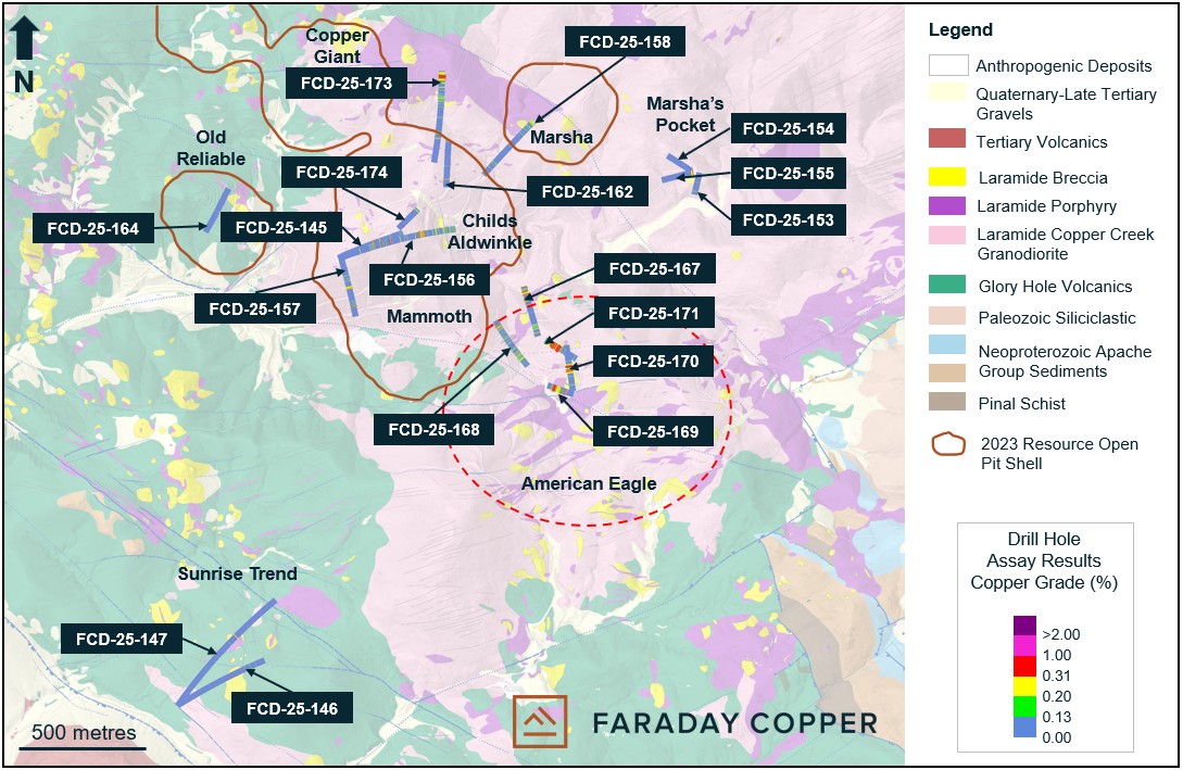
Note: The open pit shell is based on constraints used in the Mineral Resource Estimate ("MRE") as presented in the Copper Creek Project Technical Report1.
Note: The open pit shell is based on constraints used in the Mineral Resource Estimate ("MRE") as presented in the Copper Creek Project Technical Report1.
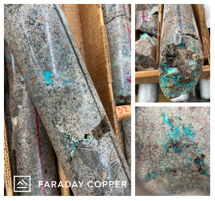
Table 1: Selected Drill Results
Drill Hole ID |
From |
To |
Length |
True Width |
Total Cu |
Sol Cu |
Sol Cu / Total Cu |
Au |
Ag |
Mo |
(m) |
(m) |
(m) |
(m) |
(%) |
(%) |
(g/t) |
(g/t) |
(%) |
||
FCD-26-145 |
260.00 |
276.33 |
16.33 |
16 |
0.22 |
N/A |
N/A |
N/A |
0.66 |
0.0004 |
FCD-26-156 |
246.83 |
270.00 |
23.17 |
23 |
0.13 |
N/A |
N/A |
N/A |
0.66 |
0.0011 |
and |
314.15 |
324.00 |
9.85 |
9 |
0.25 |
N/A |
N/A |
N/A |
1.72 |
0.0010 |
and |
368.00 |
392.00 |
24.00 |
24 |
0.37 |
N/A |
N/A |
N/A |
0.76 |
0.0016 |
and |
575.00 |
622.46 |
47.23 |
47 |
0.23 |
N/A |
N/A |
0.01 |
0.62 |
0.0014 |
and |
694.00 |
838.00 |
144.00 |
144 |
0.13 |
N/A |
N/A |
N/A |
0.46 |
0.0016 |
FCD-26-153 |
93.00 |
104.80 |
13.80 |
13 |
0.13 |
N/A |
N/A |
N/A |
0.86 |
0.0004 |
and |
168.00 |
188.00 |
20.00 |
20 |
0.15 |
N/A |
N/A |
N/A |
0.46 |
0.0005 |
FCD-26-155 |
0.00 |
9.45 |
9.45 |
9 |
0.38 |
0.33 |
0.85 |
N/A |
1.73 |
0.0006 |
FCD-26-157 |
159.00 |
173.00 |
14.00 |
14 |
0.23 |
0.01 |
0.02 |
N/A |
1.13 |
0.0004 |
and |
273.00 |
285.00 |
12.00 |
12 |
0.19 |
N/A |
N/A |
N/A |
0.96 |
0.0006 |
FCD-26-158 |
91.00 |
105.00 |
14.00 |
14 |
0.13 |
0.01 |
0.05 |
N/A |
0.25 |
0.0006 |
and |
429.00 |
446.35 |
17.35 |
17 |
0.19 |
N/A |
N/A |
N/A |
0.21 |
0.0028 |
FCD-26-167 |
0.00 |
19.23 |
19.23 |
19 |
0.16 |
0.04 |
0.34 |
N/A |
0.63 |
0.0011 |
and |
32.34 |
58.00 |
25.66 |
25 |
0.15 |
0.03 |
N/A |
0.54 |
0.0004 |
|
and |
199.54 |
237.00 |
37.46 |
37 |
0.23 |
N/A |
N/A |
0.01 |
1.90 |
0.0015 |
FCD-26-168 |
78.00 |
176.00 |
98.00 |
98 |
0.14 |
0.02 |
N/A |
0.57 |
0.0007 |
|
and |
450.00 |
476.18 |
26.18 |
26 |
0.32 |
N/A |
N/A |
0.01 |
0.75 |
0.0065 |
and |
493.17 |
506.00 |
12.83 |
12 |
0.60 |
N/A |
N/A |
0.02 |
1.14 |
0.0072 |
FCD-26-169 |
30.00 |
97.00 |
67.00 |
67 |
0.30 |
0.07 |
0.24 |
N/A |
1.08 |
0.0003 |
FCD-26-170 |
72.20 |
110.00 |
37.80 |
37 |
0.35 |
0.04 |
0.14 |
N/A |
0.37 |
0.0007 |
and |
147.89 |
158.00 |
10.11 |
10 |
0.41 |
0.01 |
0.02 |
N/A |
0.84 |
0.0001 |
FCD-26-171 |
80.00 |
151.00 |
71.00 |
64 |
0.41 |
0.02 |
0.05 |
N/A |
1.11 |
0.0014 |
Including |
85.40 |
120.75 |
35.35 |
32 |
0.58 |
0.03 |
0.05 |
N/A |
1.23 |
0.0017 |
FCD-26-173 |
0.00 |
73.00 |
73.00 |
73 |
0.31 |
0.22 |
0.61 |
N/A |
0.69 |
0.0001 |
Including |
20.00 |
57.00 |
37.00 |
37 |
0.45 |
0.36 |
0.74 |
N/A |
0.91 |
0.0001 |
and |
126.00 |
171.00 |
45.00 |
45 |
0.14 |
N/A |
N/A |
N/A |
0.24 |
0.0002 |
FCD-26-146 |
No significant intercepts |
|||||||||
FCD-26-147 |
No significant intercepts |
|||||||||
FCD-26-154 |
No significant intercepts |
|||||||||
FCD-26-162 |
No significant intercepts |
|||||||||
FCD-26-164 |
No significant intercepts |
|||||||||
FCD-26-174 |
No significant intercepts |
|||||||||
Note: Soluble Copper = "Sol Cu". All intercepts are reported as downhole drill widths. Mineralization includes bulk porphyry style and breccia mineralization. True widths are approximate due to the irregular shape of mineralized domains. N/A: Not analyzed.
Table 2: Collar Locations from the Drill Holes Reported Herein
Drill Hole ID |
Easting |
Northing |
Elevation |
Azimuth |
Dip |
Target |
Depth |
Depth |
(m) |
(°) |
(°) |
(ft) |
(m) |
||||
FCD-26-145 |
548112 |
3623867 |
1273 |
066 |
54 |
Childs Aldwinkle |
1612.4 |
491.43 |
FCD-26-146 |
547389 |
3622128 |
1209 |
058 |
45 |
Sunrise Trend |
1762.3 |
537.12 |
FCD-26-147 |
547490 |
3622128 |
1210 |
035 |
45 |
Sunrise Trend |
2669.1 |
813.51 |
FCD-26-153 |
549502 |
3624214 |
1269 |
192 |
65 |
Marsha's Pocket |
716.7 |
218.45 |
FCD-26-154 |
549486 |
3624227 |
1270 |
303 |
15 |
Marsha's Pocket |
378.2 |
115.28 |
FCD-26-155 |
549484 |
3624223 |
1268 |
253 |
30 |
Marsha's Pocket |
493.0 |
150.27 |
FCD-26-156 |
548109 |
3623870 |
1273 |
073 |
53 |
Childs Aldwinkle |
2755.6 |
839.88 |
FCD-26-157 |
548111 |
3623869 |
1276 |
165 |
45 |
White Bear |
1104.4 |
336.59 |
FCD-26-158 |
548682 |
3624195 |
1245 |
043 |
48 |
Childs Aldwinkle |
1464.5 |
446.35 |
FCD-26-162 |
548539 |
3624154 |
1278 |
002 |
45 |
Childs Aldwinkle |
863.0 |
263.04 |
FCD-26-164 |
547671 |
3624154 |
1279 |
205 |
55 |
Old Reliable west |
1193.3 |
363.69 |
FCD-26-167 |
548896 |
3623576 |
1252 |
345 |
30 |
Jailhouse |
811.0 |
247.19 |
FCD-26-168 |
548853 |
3623464 |
1253 |
320 |
65 |
Jailhouse SW |
1728.1 |
526.69 |
FCD-26-169 |
549028 |
3623357 |
1287 |
290 |
20 |
American Eagle |
379.0 |
115.52 |
FCD-26-170 |
549032 |
3623362 |
1288 |
352 |
10 |
American Eagle |
614.0 |
187.15 |
FCD-26-171 |
549040 |
3623495 |
1308 |
301 |
25 |
American Eagle north |
530.4 |
161.67 |
FCD-26-173 |
548501 |
3624606 |
1338 |
180 |
45 |
Copper Giant East |
1607.2 |
489.75 |
FCD-26-174 |
548410 |
3624076 |
1306 |
225 |
45 |
Childs Aldwinkle |
499.4 |
152.22 |
Note: Coordinates are given as World Geodetic System 84, Universal Transverse Mercator Zone 12 north (WGS84, UTM12N).
Sampling Methodology, Chain of Custody, Quality Control and Quality Assurance
All sampling was conducted under the supervision of the Company's geologists and the chain of custody from Copper Creek to the independent sample preparation facility, ALS Laboratories in Tucson, AZ, was continuously monitored. The samples were taken as ½ core, over 2 m core length. Samples were crushed, pulverized and sample pulps were analyzed using industry standard analytical methods including a 4-Acid ICP-MS multielement package and an ICP-AES method for high-grade copper samples. Copper mineralized samples were also analyzed for acid and cyanide soluble copper. Gold was analyzed on a 30 g aliquot by fire assay with an ICP-AES finish. A certified reference sample was inserted every 20th sample. Coarse and fine blanks were inserted every 20th sample. Approximately 5% of the core samples were cut into ¼ core and submitted as field duplicates. On top of internal QA-QC protocol, additional blanks, reference materials and duplicates were inserted by the analytical laboratory according to their procedure. Data verification of the analytical results included a statistical analysis of the standards and blanks that must pass certain parameters for acceptance to ensure accurate and verifiable results.
Qualified Person
The scientific and technical information contained in this news release has been reviewed and approved by Faraday's Vice President, Geology, Dr. Thomas Bissig, P. Geo., who is a Qualified Person under National Instrument 43-101 - Standards of Disclosure for Mineral Projects ("NI 43-101").
Notes
1 The Mineral Resource Estimate and cutoff grades are presented in the report titled "Copper Creek Project NI 43-101 Technical Report and Preliminary Economic Assessment" with an effective date of May 3, 2023, available on the Company's website at www.faradaycopper.com and on the Company's SEDAR+ profile at www.sedarplus.ca.
About Faraday Copper
Faraday Copper is an exploration company focused on advancing its flagship copper project in Arizona, U.S. The Copper Creek Project is one of the largest undeveloped copper projects in North America with significant district scale exploration potential. Faraday has entered into a non-binding letter of intent with a subsidiary of BHP Group for the proposed acquisition of BHP's San Manuel Property, adjacent to the Copper Creek Project. The Company is well-funded to deliver on its key milestones and benefits from a management team and board of directors with senior mining company experience and expertise. Faraday trades on the TSX under the symbol "FDY".
For additional information please contact:
Stacey Pavlova, CFA
Vice President, Investor Relations & Communications
Faraday Copper Corp.
E-mail: info@faradaycopper.com
Website: www.faradaycopper.com
To receive news releases by e-mail, please register using the Faraday website at www.faradaycopper.com.
Cautionary Note on Forward Looking Statements
Some of the statements in this news release, other than statements of historical fact, are "forward-looking statements" and are based on the opinions and estimates of management as of the date such statements are made and are necessarily based on estimates and assumptions that are inherently subject to known and unknown risks, uncertainties and other factors that may cause actual results, level of activity, performance or achievements of Faraday to be materially different from those expressed or implied by such forward-looking statements. Such forward-looking statements and forward-looking information specifically include, but are not limited to, statements concerning the exploration potential of the Copper Creek property, the closing of the acquisition of the San Manuel property, and the resumption of drilling.
Although Faraday believes the expectations expressed in such forward-looking statements are based on reasonable assumptions, such statements should not be in any way construed as guarantees of future performance and actual results or developments may differ materially. Accordingly, readers should not place undue reliance on forward-looking statements or information.
Factors that could cause actual results to differ materially from those in forward-looking statements include without limitation: market prices for metals; the conclusions of detailed feasibility and technical analyses; lower than expected grades and quantities of mineral resources; receipt of regulatory approval; receipt of shareholder approval; mining rates and recovery rates; significant capital requirements; price volatility in the spot and forward markets for commodities; fluctuations in rates of exchange; taxation; controls, regulations and political or economic developments in the countries in which Faraday does or may carry on business; the speculative nature of mineral exploration and development, competition; loss of key employees; rising costs of labour, supplies, fuel and equipment; actual results of current exploration or reclamation activities; accidents; labour disputes; defective title to mineral claims or property or contests over claims to mineral properties; unexpected delays and costs inherent to consulting and accommodating rights of Indigenous peoples and other groups; risks, uncertainties and unanticipated delays associated with obtaining and maintaining necessary licenses, permits and authorizations and complying with permitting requirements, including those associated with the Copper Creek property; and uncertainties with respect to any future acquisitions by Faraday. In addition, there are risks and hazards associated with the business of mineral exploration, development and mining, including environmental events and hazards, industrial accidents, unusual or unexpected formations, pressures, cave-ins, flooding and the risk of inadequate insurance or inability to obtain insurance to cover these risks as well as "Risk Factors" included in Faraday's disclosure documents filed on and available at www.sedarplus.ca.
This press release does not constitute an offer to sell or a solicitation of an offer to buy any securities in any jurisdiction to any person to whom it is unlawful to make such an offer or solicitation in such jurisdiction. This press release is not, and under no circumstances is to be construed as, a prospectus, an offering memorandum, an advertisement or a public offering of securities in Faraday in Canada, the United States or any other jurisdiction. No securities commission or similar authority in Canada or in the United States has reviewed or in any way passed upon this press release, and any representation to the contrary is an offence.
SOURCE: Faraday Copper Corp.
View the original press release on ACCESS Newswire